Scientists are sounding the alarm over the potential for a rare but powerful earthquake along the Cascadia Subduction Zone—an event that could lead to dramatic sea level rise and devastating coastal impacts across the Pacific Northwest.
The Cascadia Subduction Zone is a 600-mile fault line stretching from Northern California to British Columbia. It marks the boundary where the Juan de Fuca tectonic plate is slowly sliding beneath the North American plate. While it remains quiet for centuries, this fault is capable of producing megaquakes exceeding magnitude 9.0—events known as “megathrust earthquakes.”
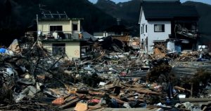
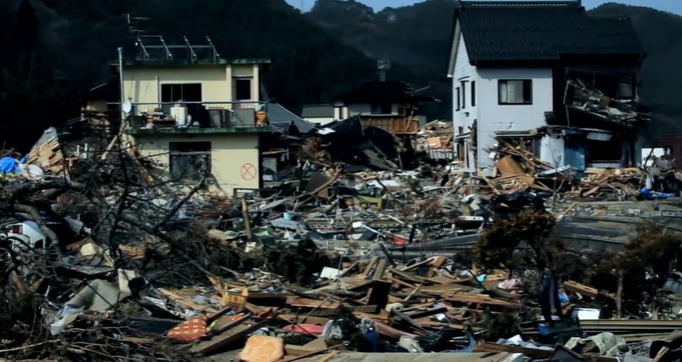
Geological records and simulations suggest that such a quake occurs roughly every 300 to 600 years, with the last major event recorded in the year 1700. That earthquake created massive tsunamis that traveled across the Pacific Ocean, even reaching Japan. Experts now warn that another large rupture is overdue.
But the concern goes beyond shaking and immediate tsunami risk. According to geophysicists, a Cascadia earthquake of this scale could cause a sudden vertical shift in coastal land—sinking it by several feet. This phenomenon, known as land subsidence, combined with tectonic movement, could instantly raise relative sea levels in certain areas, putting entire communities at risk of chronic flooding.
Unlike gradual sea level rise from climate change, the effects of an earthquake-induced shift would be immediate. Coastal towns in Oregon, Washington, and parts of British Columbia could find themselves several feet lower than before—effectively pushing shorelines inland. Saltwater intrusion could impact freshwater supplies, while marshes and estuaries would be altered or destroyed. Infrastructure like roads, ports, and buildings in low-lying zones could become unusable.
Emergency management officials emphasize the importance of preparation. “We’re talking about a scenario where the land itself drops, and then a tsunami follows. Recovery from that kind of one-two punch would take years,” said a state emergency planner. Entire cities might need to relocate, and rebuilding could cost hundreds of billions of dollars.
Scientists are also studying how the earthquake could reshape the seafloor, further influencing sea level changes. Underwater landslides triggered by the quake could displace large volumes of water, intensifying local tsunami effects and altering ocean circulation patterns. These changes could amplify storm surge impacts for decades to come.
While predicting the exact timing of the next Cascadia megathrust event is impossible, recent modeling and paleoseismic evidence show that the region is due. Experts recommend that coastal residents stay informed about evacuation routes, emergency supplies, and local hazard zones.
Ongoing efforts to install early warning systems, such as the ShakeAlert system in the U.S., offer some hope for advanced notice of seismic activity. However, many scientists stress that community preparedness and resilient infrastructure remain the most critical defenses.
In light of these warnings, urban planners and policymakers are beginning to revise building codes, zoning laws, and disaster response strategies to address the dual threats of earthquakes and rapid sea level rise.
The Cascadia Subduction Zone holds enormous power—capable of transforming landscapes and reshaping coastlines in a matter of minutes. Recognizing and preparing for this threat is essential for protecting the lives and livelihoods of millions living in its shadow.